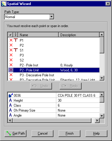
Spatial Wizard
The Spatial Wizard transfers design data from a non-GIS design (offline or template design) to the GIS. It also updates the GIS after a GIS design has been modified offline. The Spatial Wizard launches automatically if a GIS-formatted design opened in the Design Assistant contains unresolved work locations.
| Setting | Description |
|---|---|
| Path Type | Specifies the type of path that you wish to recreate with the placement of path points in the GIS window. With the Normal setting, the Spatial Wizard attempts to resolve the work locations of the source design using the points of the GIS path. Work locations are resolved in the order in which they were originally created (P1, P2, P3, etc.). The number of path points should not exceed the number of work points. The Start/End setting is used to resolve work spans in the order in which they were created. The Spatial Wizard lets you switch between the two path types at any time. |
| Resolution Pane | Displays a list of all work locations and features in the source design that require resolution. A red "X" next to the item indicates an unresolved item; a check mark indicates a resolved item. |
| Details Pane | Displays the features assigned to the selected work location or the compatible unit assigned to the selected feature. |
| Undo | Reverses the most recent action. |
| Redo | Reverses the results of the most recent Undo command. |
| Get Path | Retrieves path information from the GIS and matches it to the appropriate items in the Resolution pane. |
| Cancel | Closes the Spatial Wizard without saving any changes. |
| Finish | Saves changes made with the Spatial Wizard and provides the option of closing the wizard before resolving the remaining elements. |
| Help | Opens the Help topic for the Spatial Wizard. |